|
FIELDWALKING METHODOLOGY
A consistent approach was required for the field walking survey to ensure that the material recovered was accurately plotted and collected in a standardised way. It was also important that the process of collection must be capable of registering quantitative and qualitative comparisons across an individual site, several settlements or the entire survey region. Individual artefact positioning was considered as an approach but this had to be rejected because of resource constraints in favour of utilising a standardised grid system.
The sites selected for intensive fieldwalking were initially visually inspected by a cursory 'walk over' at 5m or 10m intervals. The point of this exercise was to ascertain and confirm if there was sufficient material to indicate concentrations of archaeological material spread across the surface of the field and also to determine the overall extent of the artifactual evidence. Any initial artifactual material was noted and bagged but not immediately retrieved until a datum-line and survey grid were laid out to cover any areas suspected of Romano-British occupation and activity. The parameter of the fieldwalking surveying grid squares (10 sq.ms or 20 sq.ms squares) was chosen because it was thought such areas are small enough to reflect archaeologically meaningful distributions and to maintain a reasonable pace of fieldwork without effecting accuracy. Every grid square was measured and plotted into secure datum points situated around the current field boundaries (fig.1).
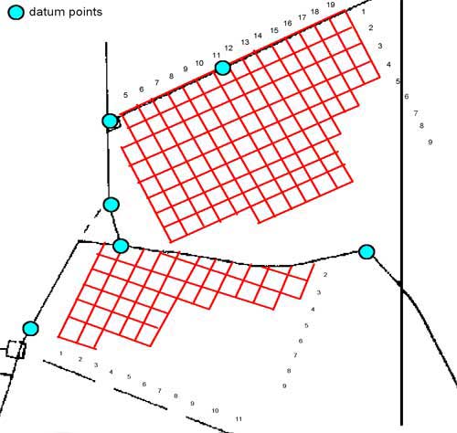
fig.1 Numerical Co-ordinate Grid Square System & Datum points
The most effective and accurate way of preparing a fieldwalking grid was to locate surveying poles along a fixed datum line which itself was securely related to a series of prominent permanent points located around the modern field boundaries. It was essential to continue recording reference points, as work proceeded, to help reduce the accumulation of errors or possibility of parallax over the full surface area of the survey grid. Every intersection of the imaginary box grid was then marked by a highly visible marker (bamboo canes with different coloured tape flags). The usual practice was to mark out three lines of survey squares then fieldwalk those parts of the grid before repeating the process.
The estimates vary concerning the amount of surface area which can be successfully visually explored by individual fieldwalkers of mixed ability working on a stint or traverse. An individual's visual acuity will depend on the operational width of the viewing band, the position and height of the head in relation to the ground and the intensity of the light available. Personal experience demonstrated that the first two influences on retrieval rates could be easily controlled. The optimum viewing conditions were achieved by restricting the observable area to a metre width and by ensuring the body was sufficiently bent at the waist to enable the head to be held in a low position parallel to the ground surface.
Unfortunately differential light conditions allied to limited access and fieldwalk time meant waiting for the best light and soil conditions wasn't always an option. However to eliminate any disparity in retrieval rates amongst the volunteers the whole of the survey grid for every site was walked a second time by the Archaeological Director who acted as a control on the consistency of recovery and restricted the potential of data bias to that of an individual.
In the fieldwork undertaken for this project the emphasis was on the intensive collection of surface scatters which required every grid square to be scrutinised in the greatest possible detail. Therefore one metre transects were employed as the standard stint width with either ten or twenty traverses forming a single grid square. The accuracy of this method was preserved by placing two surveying poles (a metre apart) either end of the stint, enabling the fieldwalker(s) to maintain by line of sight an accurate progress across the grid square (fig.2).
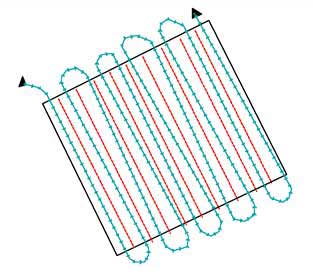
fig.2 Grid Square Traversing
All grid squares with surface scatters were then walked until the declining rate of recovery indicated the extent of the core area of occupation. A boundary of a settlement was considered as being reached if the artifacts retrieved per square returned less than two sherds of pottery for three consecutive grid squares in a given direction. This is obviously something of an arbitrary limit but without extensive access to geophysical survey and aerial photography at the time of survey it would have been difficult to state otherwise with confidence the actual parameters of a site. However subsequent geophysical survey appeared to vindicate this approach confirming a resonance with the site boundaries established during fieldwalking.
The project has established that concentrations of archaeological material reflect the underlying focal point of the main structural evidence. It also allows us to understand the nuclei of settlements and highlight the trends and character of settlements during there development. However the approach adapted to site assessment is methodologically deficient in helping to identifying inter settlement relationships and interpretation of the complex agricultural environment surrounding the surveyed area.
Those artifacts recovered from all the stints examined across an individual square were collected together and placed in a re-sealable bag on which the numerical co-ordinates of the grid square were then recorded. Collection by individual stint was not implemented, as the time taken was not reflected in any significant increase in distribution detail in relation to the volume of settlement being surveyed. All archaeological artifacts were retrieved, whilst rubble spreads and areas of soil discolouration were noted and recorded on grid plans. On completion all the bags of finds for any grid square were placed together but they were only collected from each square at the end of a fieldwalking session. The presence of bagged material acted as a visual reminder of the completed grids ensuring that duplication of fieldwork was averted. A grid square returning no finds was registered on a grid plan that was kept up to date as the work progressed. This guaranteed that all the material went through the subsequent stages of finds processing as a series of regulated units rather than as a disorganised mass.
The adoption of a grid system provided the mechanism to enable detailed comparisons to be made between the various areas and potential focal points across a site or between different classifications of settlements at a scale which was felt to be conducive to archaeological investigation. It also provided the analytical basis for interrogating the artifactual assemblages to supply the necessary data for understanding the chronological development of settlements, the extent of occupational areas and to a degree the character and level of Romanisation attained by individual sites.
A single grid square (10m x 10m) took on average twenty minutes to investigate visually and collect surface material. Surface scatters could be concentrated in relatively small areas but material was often retrieved from sites made up of several hundred grid squares covering several hectares which required very intensive fieldwork. Several experiments carried out on artifact retrieval rates across several sites indicated that on average 85% of the material visible on the ground surface was being recovered from the plough horizon.
An analysis of repeat fieldwalking surveys indicated that the removal of surface finds is unlikely to have a critical effect on the archaeological potential of individual sites unless a rigorous fieldwalking regime is maintained across several seasons. However the greater visibility of material contained in the ploughsoil on certain sites, or under repeated survey conditions at different times, as demonstrated by the variation in the amount recovered, reflects to some extent the vagaries of the modern agricultural regime (deep ploughing, subsoiling) can bias the visibility of artifactual assemblages from a site.
The most prolific diagnostic artifact recovered from the various fieldwalking surveys were the sherds of pottery. An arbitrary level was chosen to define activity of an occupational nature to prevent low sherd and fabric counts leading to any possible misinterpretation of manuring scatters from the more substantial site assemblages. Every settlement to ensure fabric visibility had to generate at least one hundred sherds of pottery for analysis, although in reality the sites undergoing survey without exception all had over a thousand sherds recovered during the fieldwalking of core areas. A range of other materials such as tile and stone roof tiles, brick, painted plaster, tesserae, querns, coins and miscellaneous small finds were equally diligently collected. On some sites the amount of tile fragments collected was far more extensive than the associated pottery assemblage. Oyster shells were also recovered but there was no systematic collection of animal bones, as their Romano-British date cannot be assured. Where appropriate, areas of soil discolouration, detectable areas of rubble and building stone, non-local materials and earthworks were recorded. A system to distinguish between different densities of building material based on a fragment count was also used to define core areas of structural remains.
Besides recording the data, other information such as the date and duration of fieldwalking was recorded. In addition the light available was assessed, the soil moisture and field condition as well as the type of crop growing were noted. Site details concerned with the physical geology and the general elevation were kept as were locational details involving the parish, grid reference and the museum PRN number and the SMR complex, element and feature designation.
|